The local story
If you drive through Seven Corners, you already know the feeling: seven roads, short merges, familiar storefronts, and a place that works mostly from behind a windshield. The New Grand Mart and Pistone’s property sits in the middle of that tangle, between Arlington Boulevard, Hillwood Avenue and the E. Broad Street side of the interchange.
Two different plans are now shaping the conversation. Eakin Properties has a rezoning and development-plan application for the 3.15-acre site. Fairfax County’s Department of Transportation has a separate four-phase plan for new roads, a rebuilt central interchange and better walking and bicycle connections. They are adjacent stories, with different applicants, approvals and schedules.
01 · The site
A 3.15-acre property could replace two recognizable businesses with a new mixed-use block.
The application covers 6320 and 6326 Arlington Boulevard, a combined 3.1501 acres at the interchange. New Grand Mart occupies the supermarket building, with Pistone’s Italian Inn behind it. The January 2026 statement reported by Annandale Today described the site as bounded by Arlington Boulevard, Hillwood Avenue, E. Broad Street and two office towers.
Eakin is asking to move the property from C-7 commercial zoning into the PRM district, which allows high-density multifamily and mixed-use development. The current PLUS record identifies the rezoning as RZ-2025-MA-00032, with a concurrent final development plan, and shows the case as In Review. That tells us where the application stands; it does not establish an approval, a demolition date or a construction start.
Start with the footprint
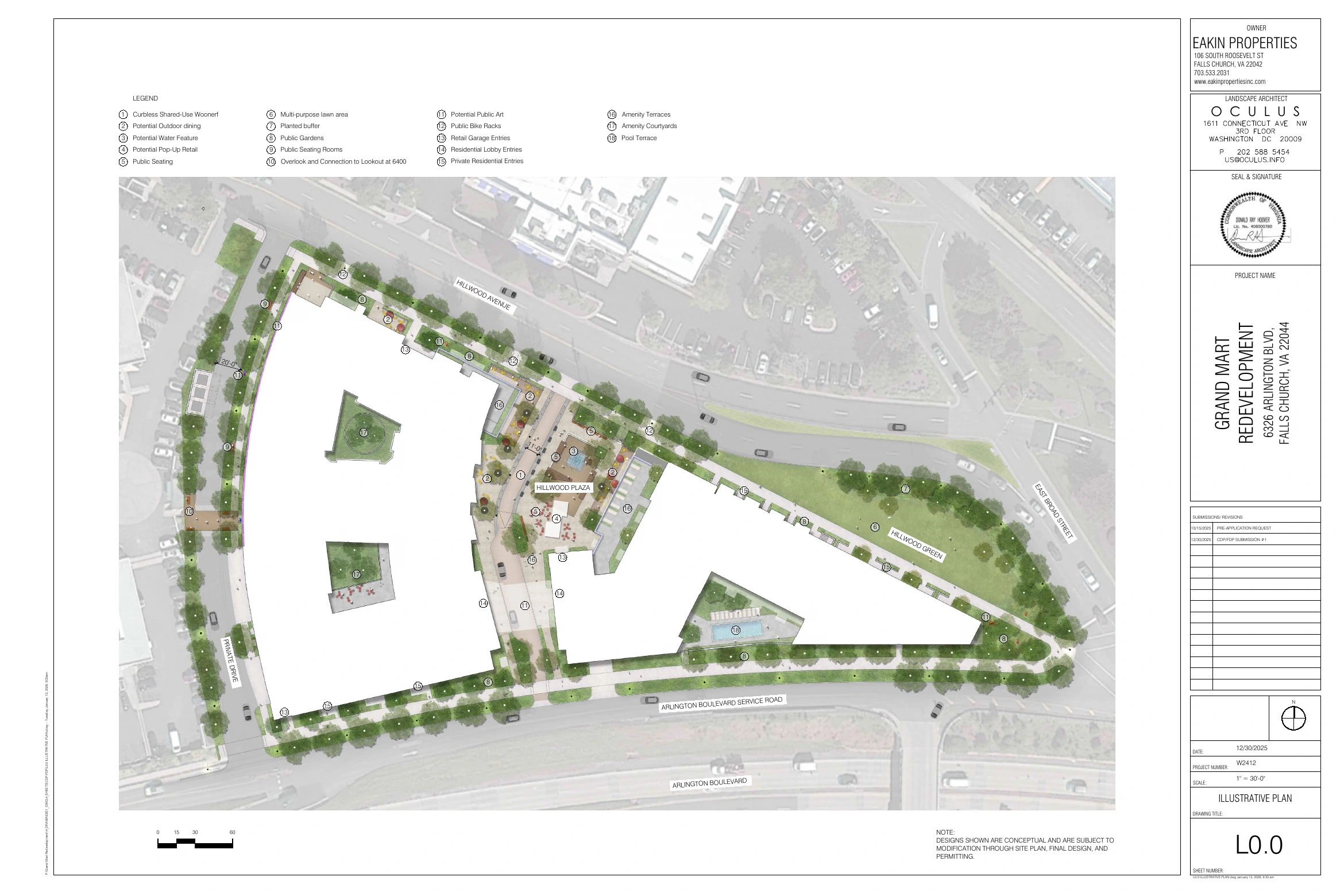
The plan is easiest to read as two wings around a central public space. Hillwood Avenue is at the top; the Arlington Boulevard service road is at the bottom.
02 · The program
The headline is roughly 450 homes and 30,000 square feet of nonresidential space.
The application’s early public description calls for about 450 apartment homes, two buildings approximately 85 feet tall, underground or structured parking, and roughly 30,000 square feet of nonresidential space. That nonresidential number is a total allocation for the proposal; it does not mean 30,000 square feet of grocery space.
The proposal also includes a central publicly accessible plaza that could host flexible programming such as markets, concerts, pop-up retail or community events. The drawings show the intended building form and public-space relationships, but they do not establish signed tenants, a guaranteed replacement grocery store or a commitment that Grand Mart or Pistone’s will return.
The plan is larger than a single storefront
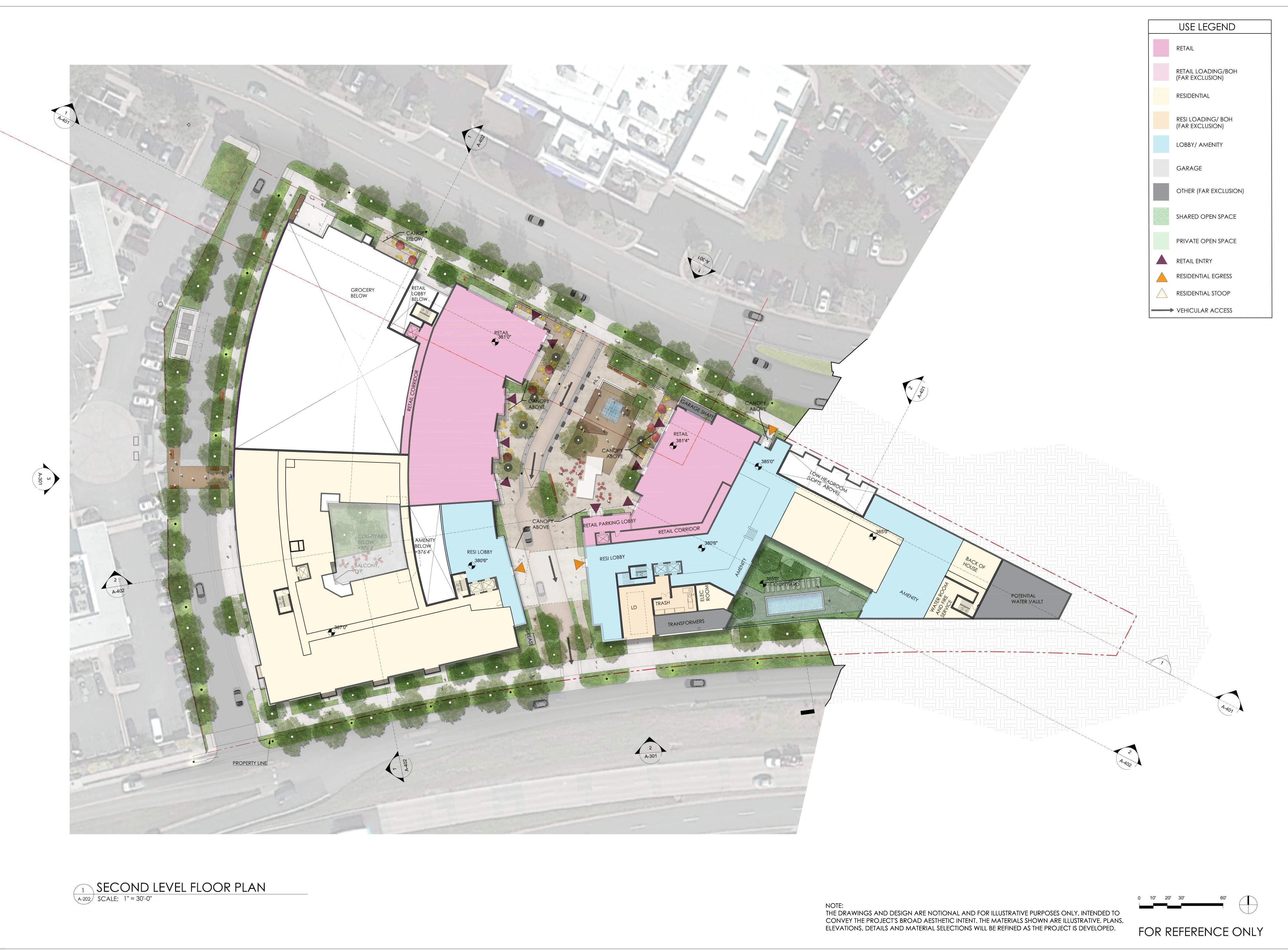
The pink retail blocks wrap the plaza level. The grocery-related labels appear on lower levels, not as proof of a signed future operator.
03 · The slope
The grocery space sits below parts of the plaza because the property falls across the site.
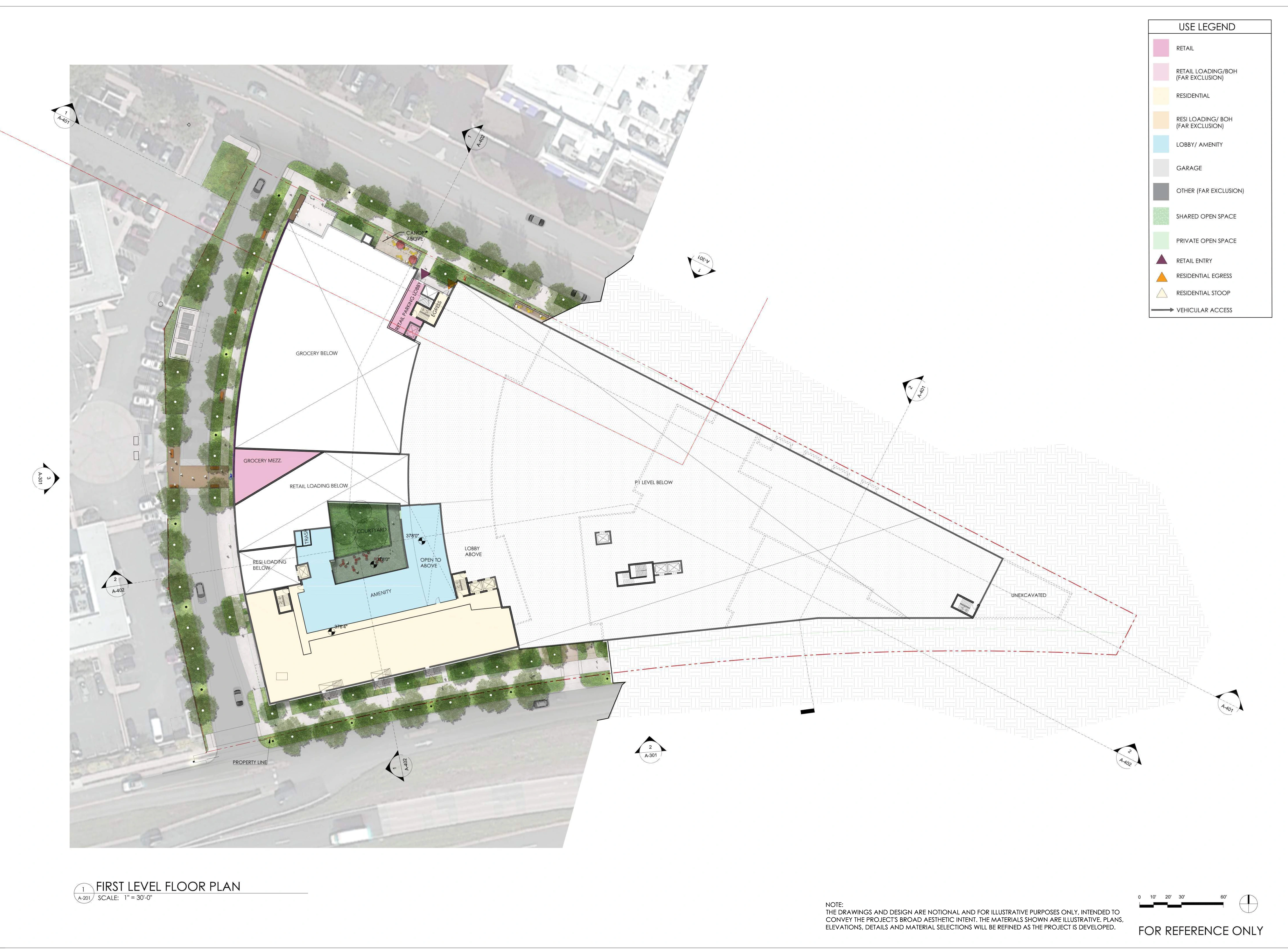
The drawings are not contradictory when one plan says grocery below and another shows retail beside the plaza. They are different levels of a sloping property. On the first-level sheet, the proposed grocery footprint is labeled below the plaza, with a grocery mezzanine near the Hillwood Avenue side.
That is the useful reading: the application envisions grocery-related space integrated into a multi-level mixed-use building. The plan does not tell us whether New Grand Mart returns, whether a new operator has signed, how the space will be leased or when the existing store would close.
Read the levels together
A single plan cannot show the full relationship between the plaza and grocery area. The application uses separate sheets for separate elevations.
04 · The connection
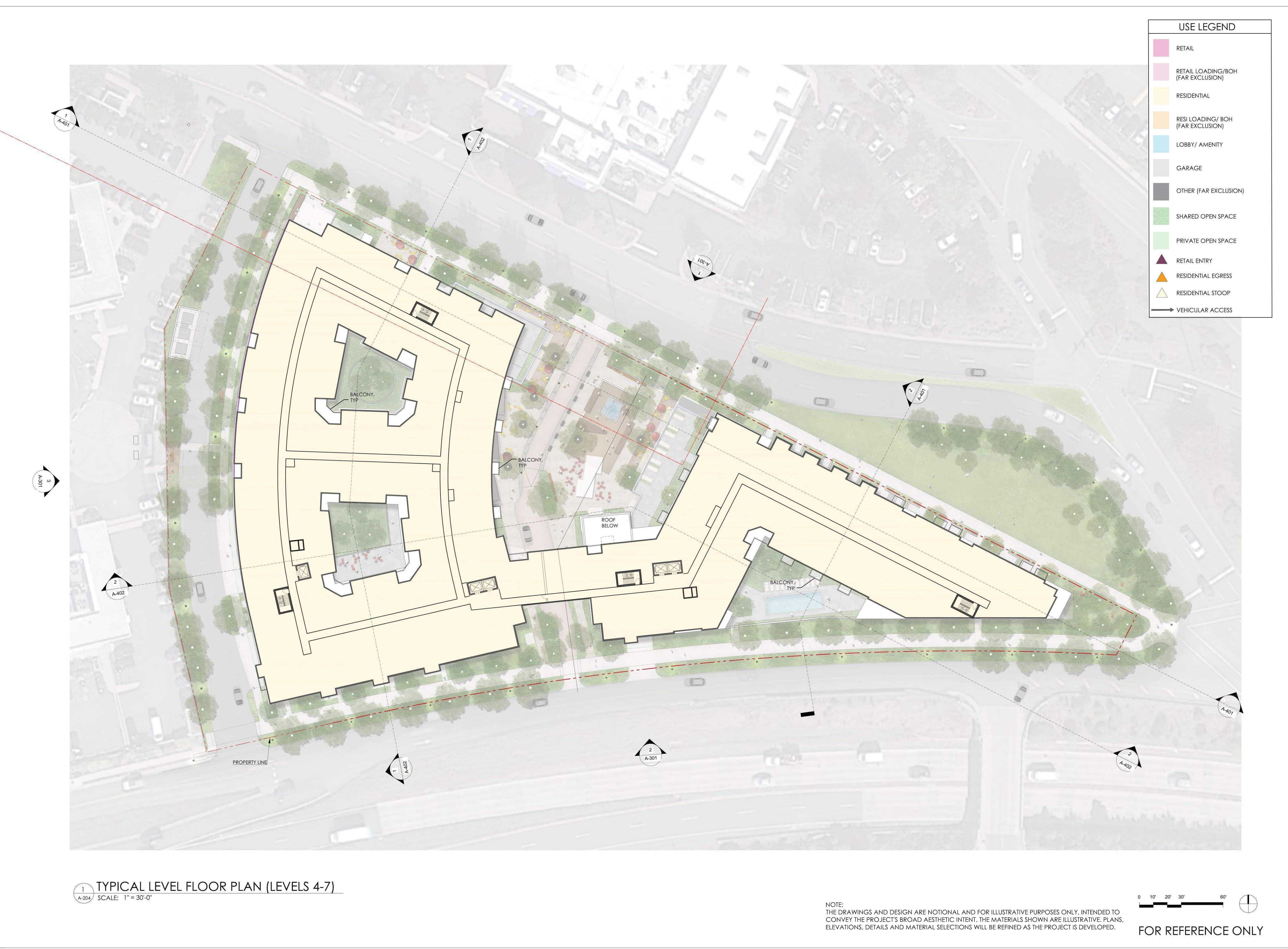
Upper residential floors span between the wings along Arlington Boulevard.
The typical-level drawing for levels 4 through 7 shows a residential footprint running along the Arlington Boulevard side and connecting the two larger wings. That is what the sheet establishes. It should not be described as a public pedestrian bridge: the plan does not establish public access, a bridge operation or an independent structure over the road.
For a reader standing at the interchange, the practical point is scale. The proposal is not a low-rise retail renovation. It is a pair of tall residential buildings organized around a landscaped center, with the upper floors forming a continuous built edge on one side of the site.
A closer look at the upper floors
The crop is provided for readability; open the full drawing for the complete footprint and legend.
05 · Hillwood Plaza
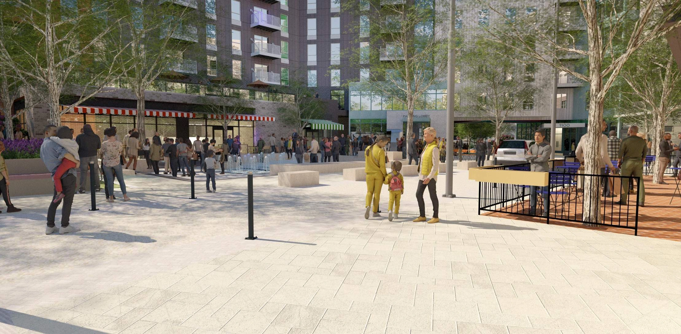
The public-facing idea is a plaza between the buildings.
The landscape plan calls the central space Hillwood Plaza and shows public seating, a potential water feature, public art, a multi-purpose lawn area, public bike racks and retail entries. It also labels private residential entries, amenity courtyards and a pool terrace. In other words, the proposal mixes public-facing space with resident-only areas.
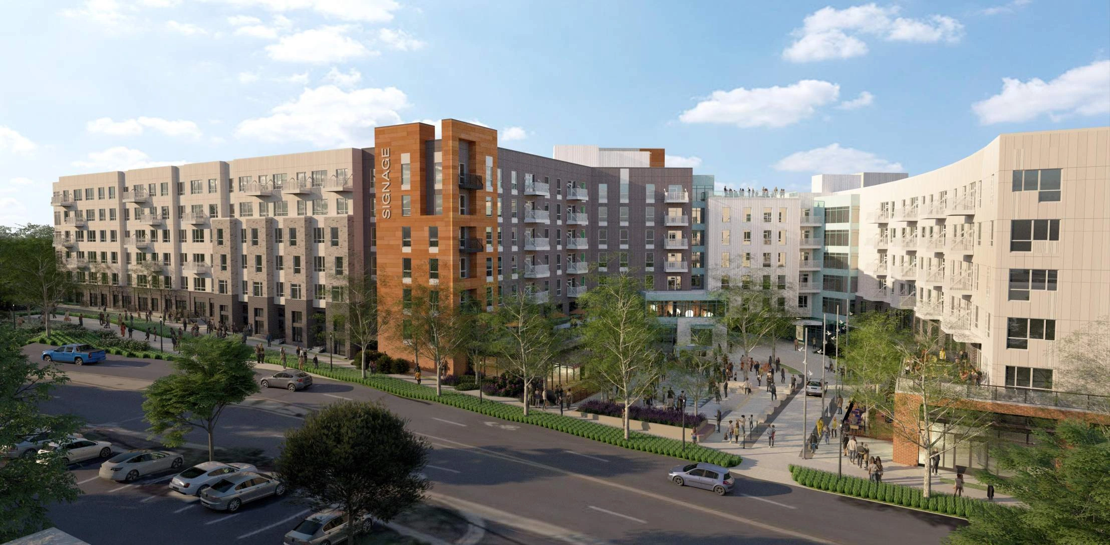
The street view is a design illustration, not a photograph of a finished place. It helps explain the intended experience: storefronts opening onto a walkable center, trees and seating breaking up the hardscape, and building entrances facing into the plaza. Whether the final built space looks this way depends on approvals and later design work.
The center of the proposal
The plaza is the part of the plan meant to be experienced on foot. Its final details would be settled through later review and permitting.
06 · The road plan
The Ring Road is a separate public project with four recommended phases.
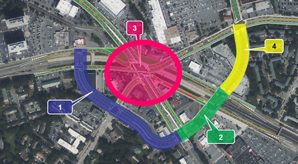
Fairfax County’s Seven Corners Phasing Study is about the transportation network, not the Eakin property. The county says Phase 1 would build a Ring Road on the west side of the interchange between Route 50 and Route 7; Phase 2 would continue it on the south side; Phase 3 would rebuild the central interchange above Route 50; and Phase 4 would complete the east side toward Wilson and Roosevelt boulevards.
The official overview map uses colors and numbered callouts to show the phasing. The large magenta circle is a graphic emphasis for Phase 3. It is not a literal circular road or proof that a roundabout is planned.
One interchange, four phases
The county’s phasing study is a long-range transportation plan. Its 2030 and 2045 analysis years are modeling horizons, not promised completion dates.
07 · Phase 1
West: build the first Ring Road segment before rebuilding the hardest intersection.
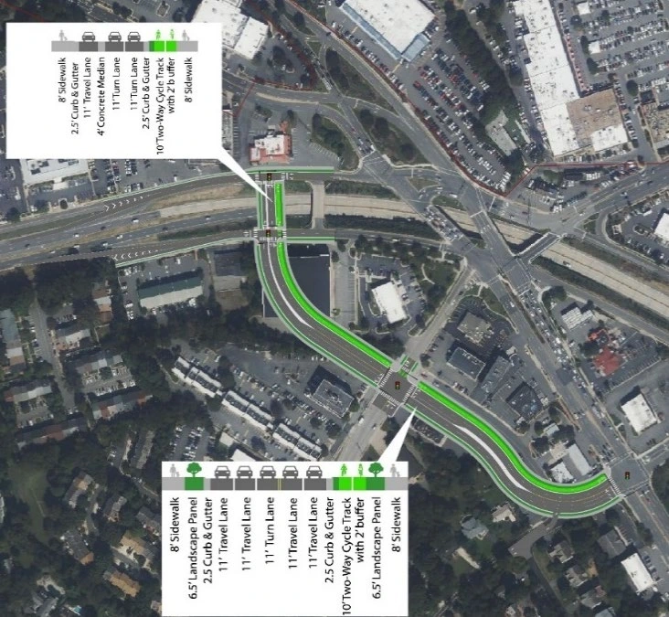
FCDOT identifies Phase 1 as the segment from Arlington Boulevard on the west to Route 7 on the south. The purpose is sequencing: shifting some travel demand away from the central interchange and creating a route that can help carry detours during later bridge and intersection work.
The county estimates Phase 1 at roughly $130 million to $140 million. NVTA’s FY2024–29 program awarded $122.2 million for preliminary engineering, design, right-of-way acquisition and construction for the first phase. Funding advances the project; it does not mean construction is underway at the filming site.
08 · Phase 2
South: extend the Ring Road and move more local traffic around the interchange.
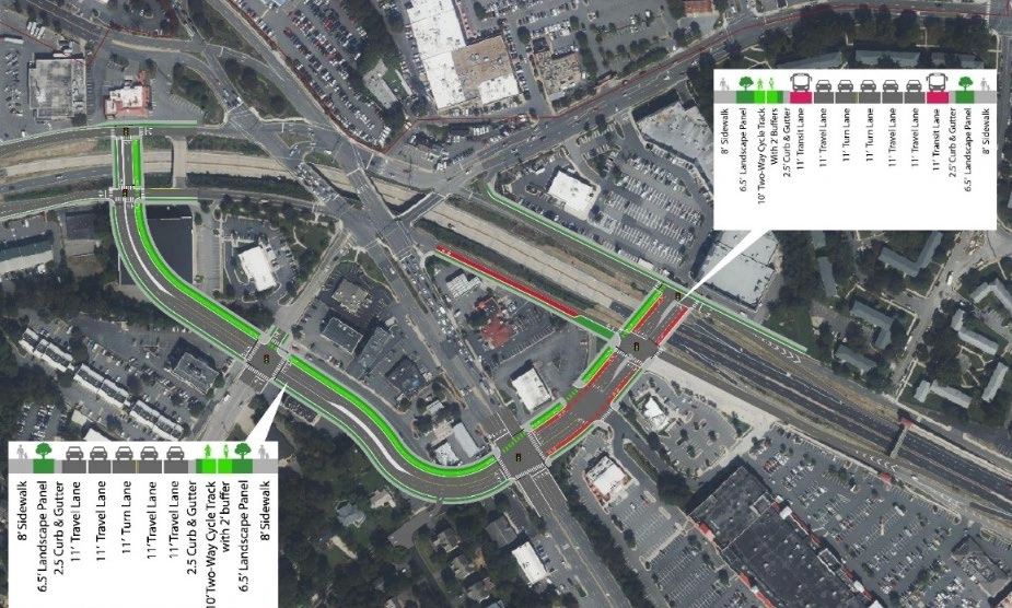
Phase 2 continues the Ring Road on the south side between Route 7 and Route 50. The later-phase drawings show cumulative improvements, so the green lines are not an entirely separate road appearing from nowhere; they build on earlier work.
The county says funding for Phases 2, 3 and 4 will be pursued after Phase 1 funding is secured. That is why it is useful to call these recommended phases rather than promise a four-part construction schedule.
09 · Phase 3
Central: simplify the seven-way tangle above Route 50.
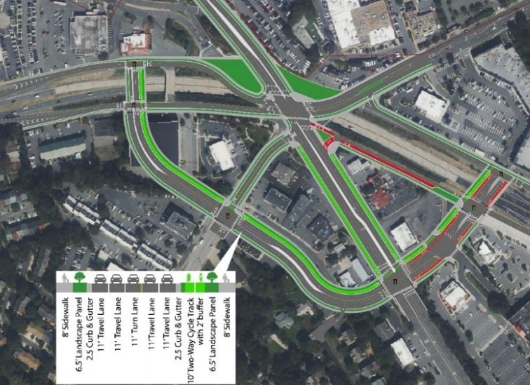
Phase 3 is the central interchange rebuild around Route 7, Wilson Boulevard, Sleepy Hollow Road and the Route 50 service roads. The county’s stated goal is four points of entry rather than today’s seven, with confusing travel movements and short merge areas removed.
The central work comes later for a practical reason: bridge replacement and major intersection construction need detour routes. FCDOT says the first Ring Road segments help shift traffic before that disruption. The concept remains subject to detailed engineering, environmental work, property acquisition and future funding.
10 · Phase 4
East: complete the network toward Wilson and Roosevelt boulevards.
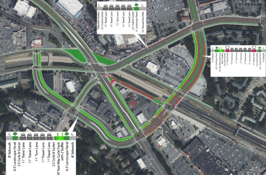
Phase 4 completes the east side of the Ring Road between Route 50 and the Wilson Boulevard/Roosevelt Boulevard intersection. Like the other later-phase drawings, it should be read as a cumulative future condition rather than a standalone promise of immediate roadwork.
The county’s public FAQ says the full project depends on local, state and federal funds, detailed design, utility coordination and right-of-way acquisition. The study’s 2045 horizon describes a modeled future network; it is not a delivery date.
11 · On foot and by bike
The transportation plan is designed for more than cars, but its pedestrian map is still a planning document.
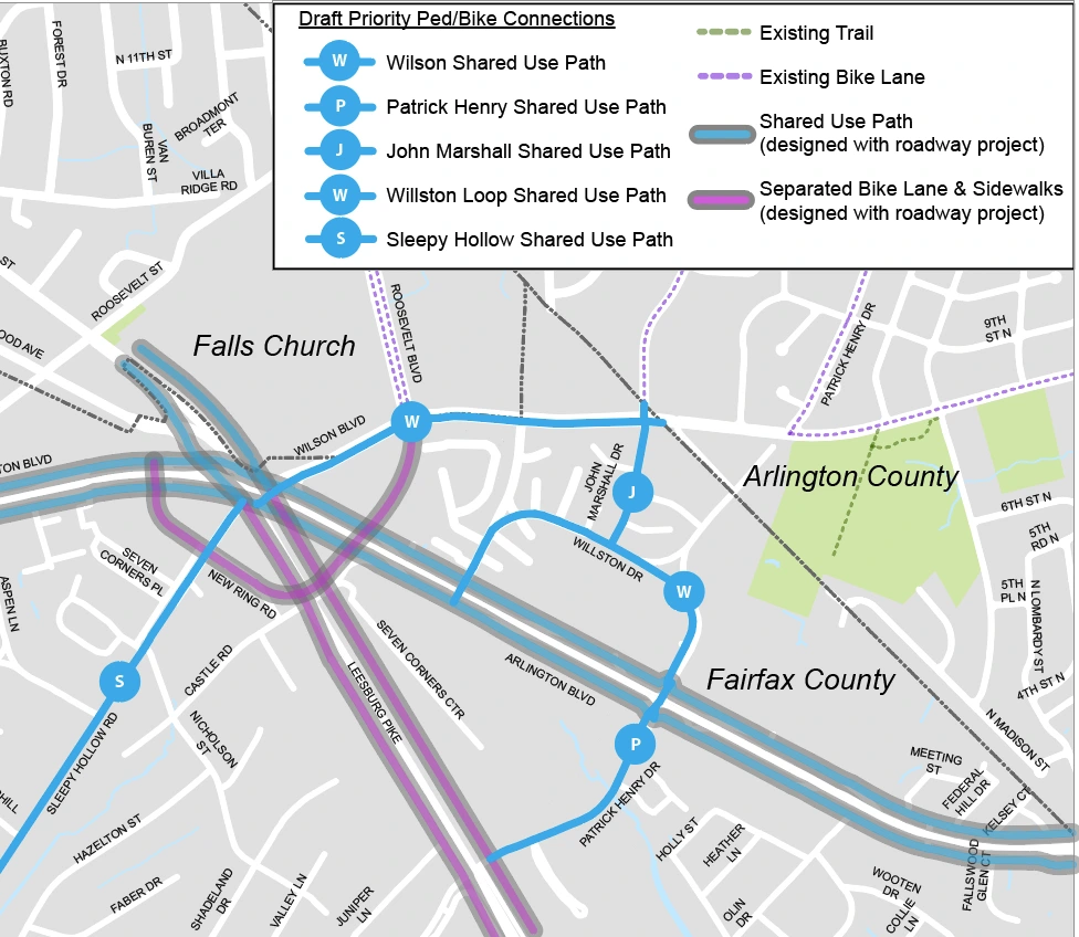
FCDOT says the reconstructed network would include wide sidewalks, dedicated two-way cycle tracks along the Ring Road and Leesburg Pike, and shared-use paths on other streets. The county says the cycle track would run inside the Ring Road to reduce conflicts with Arlington Boulevard ramps and sit near the transit center when it moves in Phase 2.
The study’s bicycle and pedestrian figure labels draft priority connections such as Wilson, Patrick Henry, John Marshall, Willston Loop and Sleepy Hollow shared-use paths. Those lines show the intended network; they do not mean every path is funded, designed or open today.
12 · What happens next
The building application and the road program now have different next steps.
For the private redevelopment, the next meaningful signals are county review, revisions, a rezoning decision, an approved final development plan and later site-plan or building permits. The PLUS record currently identifies the rezoning as In Review and shows a May 2026 traffic-impact-analysis determination. The public record does not establish that demolition or construction is imminent.
For the road plan, Phase 1 has regional funding attached to engineering, right-of-way and construction, but the county still describes design, utility coordination and property acquisition as steps before work can start. The remaining phases are recommended future work with funding to be pursued later. The two plans may influence the same intersection, but neither one automatically approves or schedules the other.
Why this matters locally
Seven Corners is being discussed as if one giant project is about to appear. The record is more specific: a private redevelopment application is under review on the Grand Mart and Pistone’s site, while a separate county transportation program is being funded and designed in phases. The local question is whether the new homes, plaza, roads and safer connections arrive in a sequence that works for the businesses and neighborhoods already here.
Which part of the proposal would change your daily life most: the buildings, the plaza, the grocery space or the road network?
Sources and further reading
Where the reporting comes from.
This article draws on public records, official statements, and attributed local reporting. Each link opens the original source.
- Fairfax County PLUS: RZ-2025-MA-00032 and concurrent final development plan ↗
- Annandale Today: proposed Seven Corners mixed-use project, January 7, 2026 ↗
- Annandale Today: more details on the proposed Seven Corners project, July 6, 2026 ↗
- Fairfax County: Seven Corners Phasing Study final report and FAQs ↗
- Fairfax County Department of Transportation / Kittelson & Associates: Seven Corners Phasing Study final report, June 2023 ↗
- Northern Virginia Transportation Authority: FY2024–29 program and Seven Corners Ring Road funding ↗
- Eakin Properties: company and project materials ↗