The local story
The most important part of Richmond Highway’s next transit line may be what you will no longer have to do: sit on a bus in the same traffic queue as everyone driving beside you. That is the promise behind The One, the planned bus rapid transit connection between Huntington Metro and Fort Belvoir.
It is also a major reconstruction project with real consequences before opening day. Utility crews, altered business entrances, property acquisition and coordinated road widening come first. As of October 15, 2026, utility relocation is underway; the county’s latest newsletter targets full service in 2033. Here is how to read the plans, what is actually changing and which decisions still matter.
Start with the route
Nine stations. One connection to Metro.
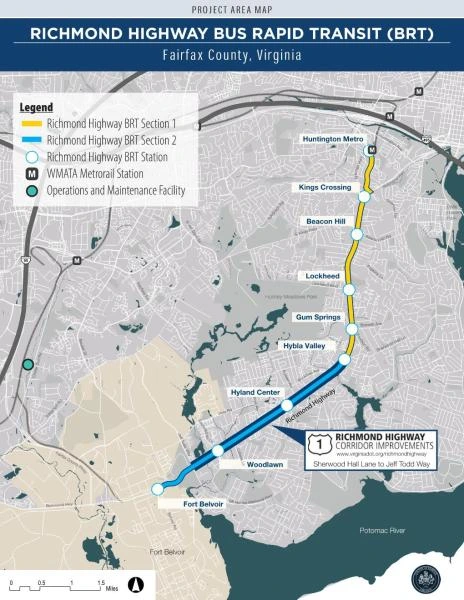
The current project runs 7.4 miles along North Kings Highway and Richmond Highway. Huntington is the northern transfer point to Metrorail; Fort Belvoir anchors the southern end. Between them, stations serve the corridor’s residential areas, commercial centers and public services. This is the approved project to follow when judging opening dates and station locations.
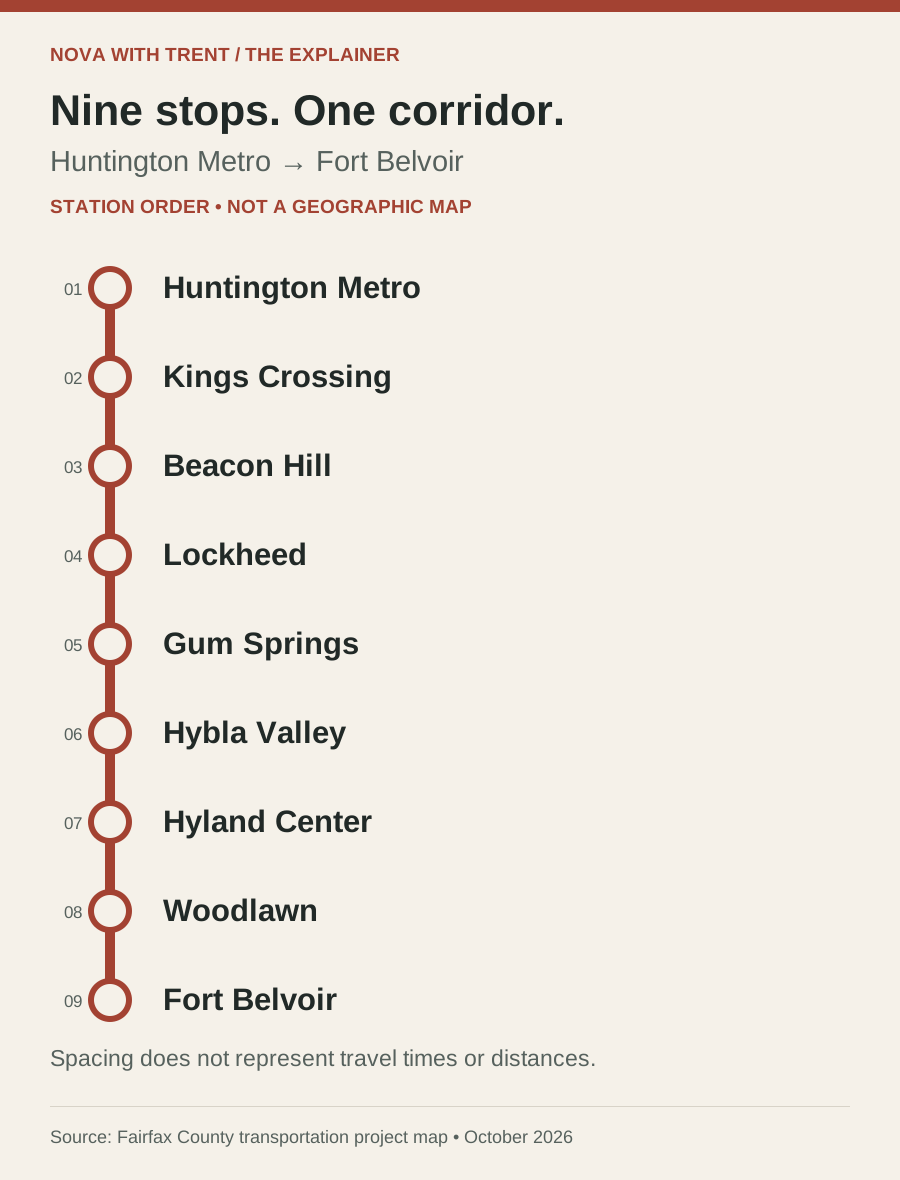
The stations, north to south, are Huntington, Kings Crossing, Beacon Hill, Lockheed, Gum Springs, Hybla Valley, Hyland Center, Woodlawn and Fort Belvoir. Read that sequence against the official map before assuming the closest station name means the shortest walking route. The side of the highway you start on, the crossing and the platform entrance all affect the real trip.
For a household considering the corridor, try a practical exercise: identify the likely station, trace the actual walk from your front door, and then think about the Metro transfer at Huntington. A straight-line distance on a listing map cannot tell you how comfortable that journey will feel. The same exercise helps employers understand whether the investment reaches their staff’s daily travel patterns.
The planned nine-station corridor
Follow the stops from Huntington to Fort Belvoir
Why a bus can be different
The benefit comes from the lane, the signal and the boarding process.
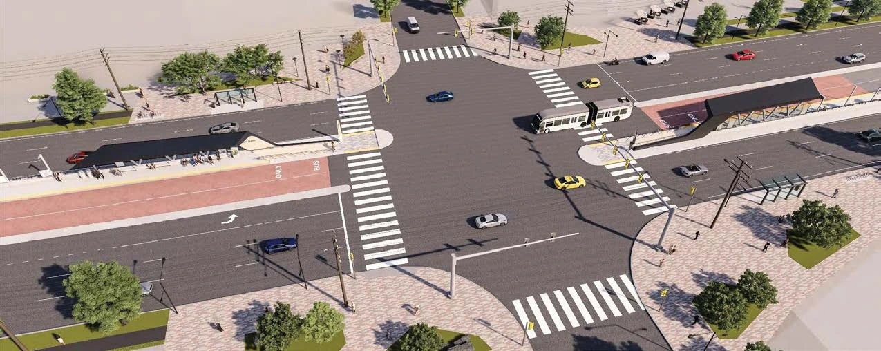
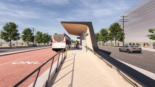
A bus with a new paint scheme still gets stuck if the street works exactly as before. BRT changes the infrastructure and operating experience around the vehicle. County materials describe dedicated lanes, signal priority, improved boarding and information systems as complementary parts of the service.
Think of a trip as a series of small delays: reaching the stop, waiting, paying, boarding, joining traffic and getting through intersections. The proposed design tackles several of those delays together. Signal priority can help a bus through an intersection; it does not mean every traffic light turns green immediately. Better boarding reduces time at the platform, while arrival information helps riders plan.
Most of The One is planned in dedicated lanes, with mixed traffic on portions of the northern end. That qualification matters when looking at reliability. Fares are not finalized. A rendering is useful for understanding the experience, but it is not a published timetable or a promise about the cost of a future commute.
| Feature | What it is intended to change |
|---|---|
| Dedicated bus lanes | Reduce time spent in general traffic queues. |
| Signal priority | Help buses move through intersections more efficiently. |
| Payment before boarding | Reduce delays caused by collecting fares at the bus door. |
| Improved platforms and boarding | Make entry easier and reduce time stopped. |
| Real-time information | Help riders understand when the next bus will arrive. |
A planned station experience
A bigger corridor plan
The bus project and the road project are connected, but their schedules differ.
The One sits within Embark Richmond Highway, the broader effort to coordinate transit, roadway changes and land use. The county adopted the Embark Comprehensive Plan amendment on March 20, 2018. Its purpose is a corridor where people have useful choices about walking, cycling, driving and taking transit, rather than treating every individual project as an isolated improvement.
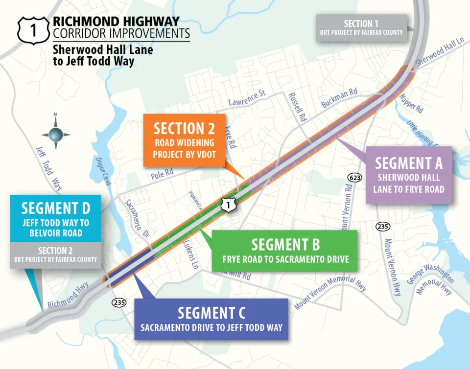
VDOT is rebuilding roughly three miles between Sherwood Hall Lane and Jeff Todd Way. Its current map separates that southern work into Segment A, Sherwood Hall Lane to Frye Road; Segment B, Frye Road to Sacramento Drive; and Segment C, Sacramento Drive to Jeff Todd Way. The county’s BRT work continues farther south toward Fort Belvoir.
That explains why you can see one date for road construction and another for the BRT system. VDOT builds roadway infrastructure and space for transit in its portion; the county delivers the BRT facilities. The map below is particularly useful because older documents use earlier phase names. Match the street limits, not just the letter or color, when comparing announcements.
Who is rebuilding which part of Route 1?
What happens first
Utility relocation is the construction story you can see now.
The county’s construction page identifies utility relocation as the current phase. Underground pipes and cables, along with overhead poles and wires, must move out of the footprint of future improvements. This is essential preparation: the visible work does not mean the finished stations are already being built.
Some work takes place along service roads, the smaller parallel roads beside Richmond Highway. The county warns that certain sections will close permanently and some entrances will move. Its August notices identified access changes near McDonald’s at 6239 Richmond Highway, Fairfield Inn and Suites at 6421 Richmond Highway and KFC at 7521 Richmond Highway. Check the live notice for your specific destination instead of assuming an old entrance still works.
The August 2026 newsletter says homes, businesses and services will remain accessible, although access routes may change. For a business, that makes customer directions, delivery instructions and employee parking practical concerns now. Before sending someone to a familiar driveway, check the latest construction notice and the signs on site. Access being maintained does not mean access remaining identical.
Keep the dates straight
2033 is the service target. There are several construction milestones before it.
The August 2026 county newsletter sets out the current sequence: utility relocation and right-of-way work continue in 2026, county project design is targeted for completion by year-end, BRT corridor construction begins in 2028 and full service follows in 2033. The newsletter explicitly says dates can change. A design target should not be reported as completed without a later confirmation.
VDOT’s October 9, 2026 update provides separate starts for its road segments. Those dates are helpful for anticipating where the next substantial disruption may occur, but they do not describe when passengers can board The One. Utility relocation, road construction, station work and passenger service are different milestones.
When a new announcement appears, ask two questions: which agency issued it, and what exactly is starting or finishing? That prevents a road contract award from being mistaken for a transit opening. It also makes schedule changes easier to understand without treating every revised phase as a brand-new project.
| Milestone | Current target / status |
|---|---|
| County utility and property work | Underway in 2026. |
| County project design | End of 2026 target; completion not confirmed here. |
| VDOT Segment C road construction | Mid-2027 target. |
| County BRT roadway / station construction | 2028 target. |
| VDOT Segment B road construction | Mid-2028 target. |
| VDOT Segment A road construction | Early 2029 target. |
| Full BRT service | 2033 target; county FAQ says late 2033. |
What the station will feel like
Wing-shaped canopies, local history and a revised bus choice.
The December 2025 open-house boards show the planned station architecture and intersection experience. They are concept materials, not photographs of a completed stop. Most canopy designs draw on the corridor’s aviation history; the terminal stations differ. Look at the relationship among the shelter, platform, crossing and bus lane rather than reading every rendered detail as final.
Those same boards record a meaningful vehicle change: the project plans to use hybrid buses instead of its earlier battery-electric proposal, citing production and reliability challenges in that industry. This is why dated project materials matter. An older electric-bus illustration can remain online after the delivery strategy changes.
The station windscreens also carry local stories. Beacon Hill’s selected artwork uses air-mail colors and imagery connected with Beacon Field and its guiding tower. Gum Springs’ design follows the community from its founders and the hardship of slavery toward its future. Kings Crossing looks further back to the land and its original inhabitants. These are specific neighborhood references, rather than interchangeable transit decoration.
The county’s executive committee approved station artwork selections on June 10, 2026 after public feedback. Integration into the architecture can still require adjustments. The Beacon Hill panel below is an approved artwork selection; it is not a photograph of an installed station.
Beacon Hill’s aviation history becomes station art

The investment
A cost estimate is not the same as a completed funding agreement.
The county currently estimates the BRT project at approximately $978.8 million. The FAQ says federal grant funding remains pending. The December 2025 boards document entry into the Federal Transit Administration’s Capital Investment Grants engineering phase in June 2024 and inclusion in its November 2025 funding-recommendations report. Those steps advance the project; neither statement should be rewritten as proof that every federal dollar has been secured.
The number also needs a label. VDOT separately lists its Richmond Highway road-improvement project at $505 million. These are agency project estimates for related scopes. This article keeps them separate rather than presenting an unsupported combined total or implying one figure buys every corridor improvement.
For readers, the useful funding question is what has been committed, what remains contingent and whether the next contract can proceed on the announced schedule. A final grant agreement, an awarded construction contract and a revised official schedule provide stronger evidence than an attractive rendering or a repeated opening-year headline.
What it means for the neighborhood
The walk to the station and the land around it both matter.
Embark ties the transit investment to a longer-term land-use framework. A transit corridor works differently when daily destinations connect to stations by comfortable walking routes. That is why sidewalk continuity, bicycle facilities, crossings and the layout of nearby development deserve as much attention as the bus itself.
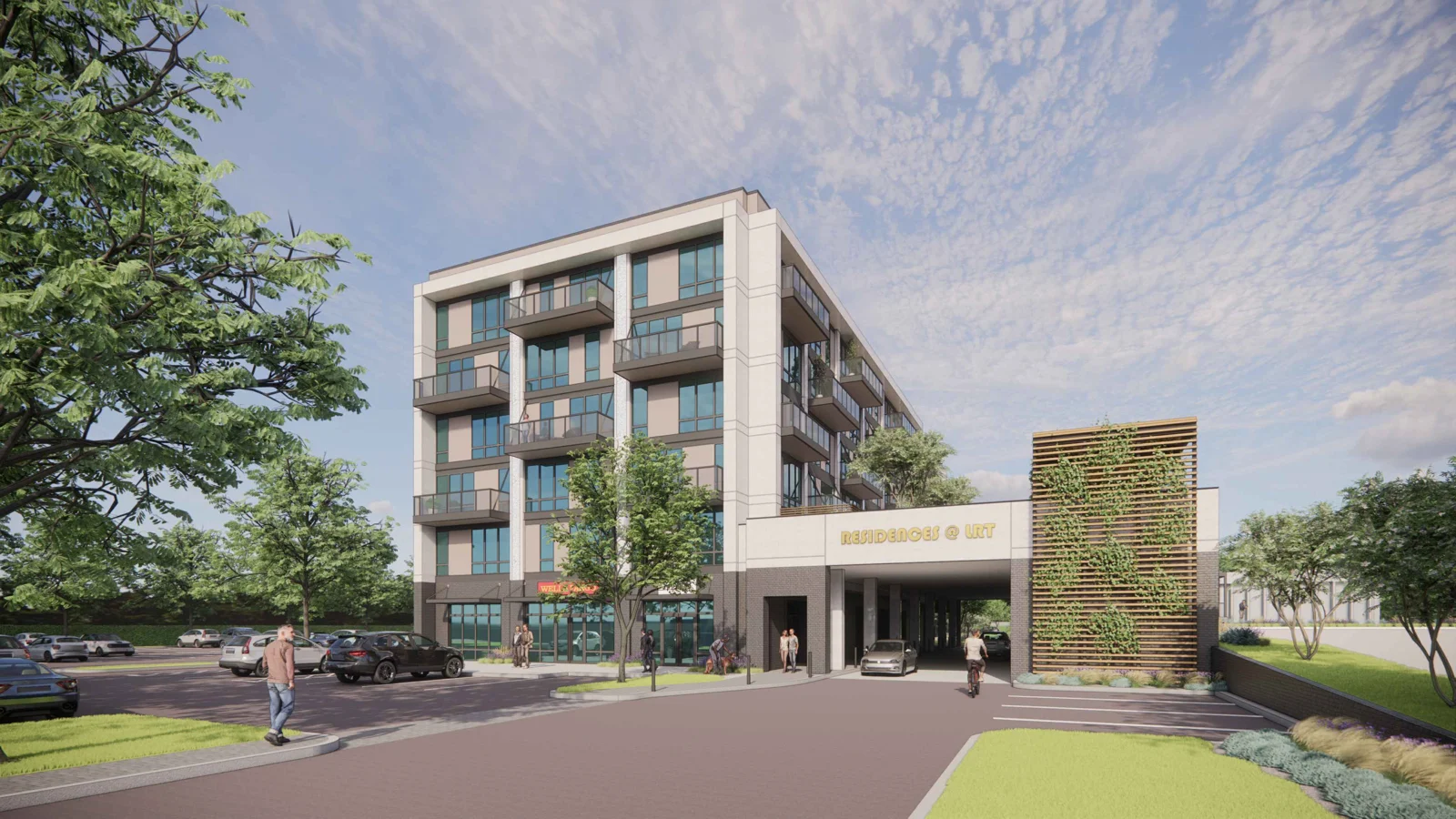
It is still important to distinguish a comprehensive plan from a completed building. The 2018 amendment established planning direction; it did not construct every station-area project or establish a construction date for every parcel. Each nearby redevelopment deserves its own review of approvals, financing, phasing and actual activity on the ground.
Property impacts are also specific. The county’s right-of-way page provides a process and contact information for owners and occupants whose properties may be affected. If you own or lease near the work, ask about the exact parcel, driveway, easement or acquisition involved. A corridor overview cannot answer that reliably for an individual address.
My practical read for buyers and owners: evaluate the neighborhood as it functions today, then treat future transit as a dated plan with milestones to monitor. Walk the route, understand access during construction and consider how long you expect to stay. A future station can be a useful part of that conversation without becoming a guaranteed price increase or a substitute for checking the property itself.
How to follow it
Use the document that answers your actual question.
For changing entrances and service-road closures, start with the county’s construction updates. For the southern widening segments, use VDOT’s project page and map. For a proposed station layout, open the county’s project materials rather than relying on a compressed social-media graphic. These sources address different questions and are most useful together.
For property-specific impacts, the county lists DOTBRT@fairfaxcounty.gov and 703-877-5600, TTY 711. Include the address, nearest intersection and a clear description of the concern. Asking whether a particular driveway changes is more actionable than asking generally what will happen to Route 1.
Subscribe through the official project homepage for future notices. Older meeting announcements and artwork surveys are a record of engagement, not proof that a comment window is still open. The materials below let you check the plans yourself and follow the next concrete decisions: funding, contracts, updated access notices and a confirmed operating plan.
Why this matters locally
The One could change how Richmond Highway connects to Metro, while the road, walking and cycling improvements reshape daily trips. The immediate story is construction access; the long-term test is whether the completed service makes ordinary journeys more dependable.
Sources and further reading
Where the reporting comes from.
This article draws on public records, official statements, and attributed local reporting. Each link opens the original source.
- Fairfax County: The One project FAQ ↗
- Fairfax County: current construction and access updates ↗
- Fairfax County: August 2026 project newsletter ↗
- Fairfax County: December 2025 open-house boards and station renderings ↗
- VDOT: coordinated Richmond Highway corridor improvements ↗
- Fairfax County: project homepage, map and update subscriptions ↗
- Fairfax County: selected Community Charm station artwork ↗
- Fairfax County: how bus rapid transit works ↗
- Fairfax County: adopted Embark Richmond Highway plan amendment ↗
- Fairfax County: property impacts and right-of-way contacts ↗